1998.131.191.1 (Film negative)

1998.131.191.1 (Film negative)
Frederick Spencer Chapman
Frederick Spencer Chapman
August 22nd 1936
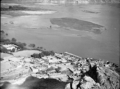
Tsangpo Valley Region > Chushul
1998.131.191.1
81 x 111 mm
Negative film nitrate
Donated 1994
Faith Spencer Chapman
British Diplomatic Mission to Lhasa 1936-37
Frederick Spencer Chapman
C.11.12 [view film roll]
SC.T.2.191.neg
In Negative - '12' is printed on the negative film on the left hand side [MS 17/1/2005]
Technical Information - This image was taken with a quarter plate Zeiss Nixe film or film pack camera as the negative is quarter-plate sized. See Chapman Lhasa The Holy City [London: Chatto & Windus, 1938] for a description of the still and cine cameras that Chapman used as Mission photographer [MS 25/2/2005]
Manual Catalogues - Caption in Chapman's hand-written list of negatives made whilst on the Mission to Lhasa, 1936-7 [See PRM Manuscripts Collection]: 'Ditto [From Chusul dzong and valley] down onto Chusul and beyond ' [MS 12/03/2006]
Other Information - Related Images: All the images prefixed with 'C.11.' seem to have been taken en route to Lhasa at the end of August 1936 and comprise a group of negatives containing images of Chushul, including a panorama [MS 12/03/2006]
Other Information - Traditionally Tibetan houses would be built in square around a courtyard and many houses of this design can be seen in this image. Two large houses can be seen on either side of the field by the waters edge and these appear to be the two largest houses in the village. The river appears to be in flood because trees are visible in the middle of the expanse of water [TS 20/1/2005] [MS 20/1/2005]
Other Information - Related Images: Images prefixed with 'C.11' comprise a group of negatives containing images of Chusul, including a panorama [MS 01/04/2006]
For Citation use:
The Tibet Album.
"Aerial view of Chushul"
05 Dec. 2006. The Pitt Rivers Museum.
<http://tibet.prm.ox.ac.uk/photo_1998.131.191.1.html>.
For more information about photographic usage or to order prints, please visit the The Pitt Rivers Museum.
© The Pitt Rivers Museum

