2001.59.8.91.1 (Transparency)

2001.59.8.91.1 (Transparency)
Hugh E. Richardson
Hugh Richardson
1949-50
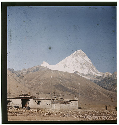
Chumbi Valley Region > Phari > Chomolhari
2001.59.8.91.1
43 x 54 mm
Transparency Colour
Donated August 2001
The executors of the estate of Hugh E. Richardson
Hugh E. Richardson
Manual Catalogues - Notes on negative album '8' - 'Potala. Colour misc.' [on front cover] [KC 9/9/2006]
Manual Catalogues - Notes on negative index '8' - Folio 91. 'Gyantse monastery' [KC 9/9/2006]
Other Information - Setting: Pha ri (phag ri) is situated at 4360 m and is one of the highest settlements in the world. The town served as a major trading centre between Tibet, Bhutan and Sikkim. It also served as the main administration centre for Western Tibet. It is surrounded by major Himalayan peaks, in the east Chomolhari is visible and in the west lies the Kunchenjunga range. (TS)
For Citation use:
The Tibet Album.
"Chomolhari from Phari "
05 Dec. 2006. The Pitt Rivers Museum.
<http://tibet.prm.ox.ac.uk/photo_2001.59.8.91.1.html>.
For more information about photographic usage or to order prints, please visit the The Pitt Rivers Museum.
© The Pitt Rivers Museum
