1998.285.694.1 (Lantern Slide)

1998.285.694.1 (Lantern Slide)
Sir Charles Bell
Sir Charles Bell
1923-1924
1998.285.694.1
81 x 81 mm
Lantern Slide
Donated 1983
St. Antony's College, Oxford
Sir Charles Bell
Sir Charles Bell; Royal Central Asiatic Society
L.289
British Library, Oriental and India Office Collections
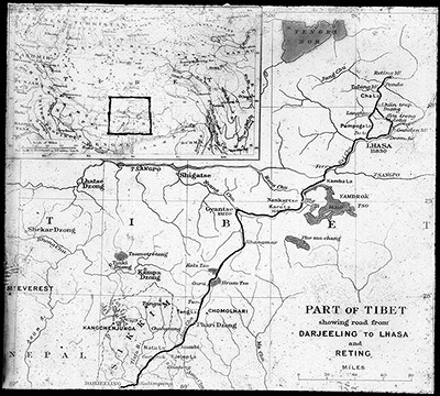
Other Information - Description: Regional map with an enlargement of the region of Tibet showing road from Darjeeling to Lhasa and Reting with the route marked by hand in red and lakes coloured in blue [MS 7/9/2004]
Contemporary Publication - Part of this map was published in 'A Year in Lhasa' in The Geographical Journal, February,1924, facing p.93:"Sketch-map of country between Lhasa and Reting". This piece was derived from a lecture given to the Royal Geographical Society in London on 3rd December 1923 [MS 10/9/2004]
For Citation use:
The Tibet Album.
"Map of Tibet"
05 Dec. 2006. The Pitt Rivers Museum.
<http://tibet.prm.ox.ac.uk/photo_1998.285.694.1.html>.
For more information about photographic usage or to order prints, please visit the The Pitt Rivers Museum.
© The Pitt Rivers Museum

